
Blastorama Breakfast Map and driving directions
 Here's a map to show you how to get to the Clover Patch Cafe on Sunday morning, Oct. 30th. at 10am. for the Blogger Blastorama breakfast.
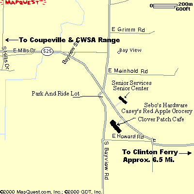
(click map for larger image)
Cross over to Whidbey Island on the Mukilteo-Clinton ferry, follow the main highway (HWY 525) North, and somewhere around 6 + miles you'll see a Red Apple Grocery and a Sebo's Hardware store on the LEFT side of the highway. You will pass a different Red Apple grocery roughly 3 miles from the ferry dock, but it's on the RIGHT side of the highway. Ignore the first one. Watch for the one on the LEFT. Turn into the parking lot for the Red Apple grocery from HWY 525. The Clover Patch Cafe is on the left end of the Red Apple building. You will be able to see it as soon as you enter the parking lot. If you see signs for Freeland, you've gone several miles too far!
If you can't make it in time for the breakfast, we will be leaving the Clover Patch at roughly 11:30 for the range, so you can meet up with us at the restaurant, and drive up to the range as a group to simplify signing you in as range guests.
If you miss us at the Clover Patch, head on up to the range, which is a little over twenty minutes away. The range is just past the Navy OLF Coupeville airfield, which will be on your left. Just past OLF Coupeville watch for the Central Whidbey Sportsman's Association sign and Safari road. Turn left onto Safari road.
You will see the club grounds and gate directly in front of you. If the gate is closed, park to the side, and walk in to the bowling pin range, which is behind the clubhouse, and to the left.
If we've moved to the pistol range, it is also on the left. If you are really late, we may be on the rifle range, which is on the right.
If you are planning to make it to the Blogger Blastorama (you DON'T have to be a blogger!) be sure to send me an email at
b l o g ( a t ) w h i d b e y ( d o t ) c o m
and we'll be watching for you.Hope to see you there!


1 Comments:
Hey, itinerary follows, listen up: 102905 Departing Lake Forest Park up Ballinger Way to Exit 179 on I-5 (passing a Liquor Store, lemme know if you need some thing from there). Motoring up to Exit 230 (Burlington, then West on SR 20 to the Deception Pass Bridge, then down the Island to Oak Harbor, check into hotel (Best Western).
Lv BW in time to make whatever destination for dinner. Return to Oak Harbor for RON. Check out of BW 103005 and proceed down-island to Coupeville for Breakfast, then Range. After Range, proceed further down-island to Clinton, get on ferry boat if dogs don't sniff all the uncleaned guns and think I'm a terrorist, ferry back to Mukilteo, motor back to Lake Forest Park and RON.
I will have an open seat in my vehicle leaving the North end of SEA on Saturday afternoon. I will have an open seat leaving Coupeville on Sunday evening, downbound for SEA.
Any SEA people needing a ride, that this itinerary fits, email me at perspac@yahoo.com
That is all.
Rivrdog, out.
Post a Comment
<< Home